To use all functions of this page, please activate cookies in your browser.
My watch list
my.chemeurope.com
my.chemeurope.com
With an accout for my.chemeurope.com you can always see everything at a glance – and you can configure your own website and individual newsletter.
- My watch list
- My saved searches
- My saved topics
- My newsletter
Wind chill
Wind chill is the apparent temperature felt on exposed skin due to the combination of air temperature and wind speed. Except at higher temperatures, where wind chill is considered less important, the wind chill temperature (often popularly called the "wind chill factor") is always lower than the air temperature. In cases where the apparent temperature is higher than the air temperature, the Heat index (HI) is used instead. Product highlight
Explanation
To understand wind chill, one must have some appreciation of the concept of a thermal boundary layer. If you dive into the ocean and come back out again, a thin layer of water will adhere to your skin. We live in an ocean of air, and air, like water, can be said to “wet” the skin or any other object that is immersed in it. Right at the surface of the skin, the adhering air is still. Because air has some internal stickiness (viscosity), there is drag between the adhering air and the air molecules farther away from the skin. As a result, near the skin or any surface there is a zone of relatively still air that may be several millimetres thick. This is the boundary layer. The boundary layer insulates your skin from the environment. If you blow on your arm, it can feel cool even though your breath is relatively warm because you have blown away the warm boundary layer air that was insulating the skin. If you do the same experiment in a hot sauna, instead of feeling cool, the spot you blow on can feel painfully hot, because you have blown away the boundary layer of sauna air that had been cooled by the skin and allowed the heat of the sauna to reach the skin more easily. In a perfect calm, if free convection could be suppressed (as it is in microgravity), the boundary layer would be infinitely thick. Add a wind, and the only still air that remains would be the air in the immediate vicinity of some surface, like the skin. The stronger the wind, the thinner the layer. Because the outer layers of still air are blown off more easily than the ones closer to the skin, when it is nearly calm, a small increase in wind speed causes a much greater thinning of the boundary layer thickness than the same increase in wind speed when the wind is already strong. Convective heat loss is really conduction through an insulating boundary layer. The insulation of the boundary layer depends on its thickness. When there is wind, the thermal resistance of the boundary layer is smaller, the heat loss is higher and the temperature of the skin is closer to the air temperature. Humans do not sense the temperature of the air. When we feel that it is cold outside, we are actually sensing the temperature of our skin. Because our skin temperature is closer to the air temperature when it is windy, we feel that the wind makes it colder outside. That is the essence of wind chill. [1] A wind-chill factor of 25° F (- 4° C) will not freeze water if the air temperature is 35° F (2° C). Water changes state according to the temperature of the body of the water. In this case, the water and air temperature are about the same — too high to freeze water.[2] DefinitionsThe Windchill Factor is the overall heat transfer coefficient of the small plastic cylinder that Siple and Passel used in their experiments, from the water/ice core at freezing point, to the environment. This number is a function of wind speed only. It had to be multiplied by a temperature difference to get the heat flow, which was called the Windchill Index, a three or four digit number. To calculate the heat loss rate of the plastic bottle, the temperature difference should be the difference between the freezing point and air temperature Because the experimenters were trying to simulate human heat loss they chose to use 30 C instead of the freezing point, hoping that this temperature would be an average for human skin in the cold. Clearly, because the thick plastic skin of the cylinder was an attempt to simulate human tissues, an internal temperature of around 37 C should have been used. It makes no sense to warn of impending frostbite with a calculation that assumes that the skin is still quite warm. However, frostbite could easily occur with a normal core temperature. Despite its serious technical shortcomings, the Windchill Index was a useful way of estimating the relative severity of different combinations of wind and temperature. Osczevski [3] showed why this was so. The Wind Chill Equivalent Temperature was originally the air temperature at which the Windchill Index would be the same if the wind was calm, which for practical purposes was set to be 4 mph (1.78 m/s) in 1964. Windchill equivalent temperatures could only be calculated for wind speeds higher than this limit. Osczevski and Bluestein's 2001 model for calculating wind chill equivalent temperature (WCET)[4] has no lower limit for wind speed. Instead, they assumed that the individual was walking at an average walking speed (3 mph or 1.34 m/s), so that even in dead still air, there was relative air motion at walking speed. However, the wind chill formula, which was created for operational reasons from the data supplied by the computer model, is only an approximation to the output of the model. It is a very good approximation over the range of wind speeds normally reported, i.e. greater than 3 mph, but it becomes inaccurate if used with wind speeds lower than about 2 mph or 1 m/s. They used an accepted engineering relationship between the wind speed and the thermal insulation of the boundary layer on the front of a cylinder to approximate the effect of wind and walking speed on the steady state heat transfer from a face, looking and walking upwind. An internal thermal resistance for the face was assumed, representing the 95th percentile value of cheek thermal insulation of volunteers, 6 male and 6 female, 22-42 years of age in experiments at a range of air temperatures and wind speeds. The higher the internal thermal resistance, the colder the skin. This leads to a paradox in which those with high internal thermal insulation lose heat less rapidly and so should experience less wind chill, but are more susceptible to facial cooling, discomfort, and frostbite. The 95th percentile value was chosen as a worst case. The method for calculating wind chill has been controversial because experts disagree on whether it should be based on whole body cooling either while naked or while wearing appropriate clothing, or if instead it should be based instead on local cooling of the most exposed skin, ie. the face. The internal thermal resistance is also a point of contention. It varies widely from person to person. Had the average value for the subjects been used, calculated WCET's would be a few degrees more more severe. The 2001 WCET is a steady state calculation (except for the time to frostbite estimates [5]) There are significant time-dependent aspects to wind chill, for cooling is most rapid at the start of any exposure, when the skin is still warm. The exposure to wind depends on the surroundings, and could be much less than is assumed in residential areas or where there are obstructions to wind flow. Wind chill is not a neat, simple package. SignificanceThe concept of wind chill is of particular significance in very cold climates such as the Arctic and Antarctic, at high altitude, at high speeds, or in very high winds. In much of North America in winter, wind chill is forecast and reported by news media. To some degree, people make decisions as to how they will dress for outdoor activity, or whether they will take part in outdoor activity based on the wind chill. This has a potential economic impact on ski operators and other outdoor recreation areas, and to merchants. Schools use the wind chill forecast to decide whether or not to let students outside for recess or lunch in cold weather. Heart patients pay attention to the wind chill, to estimate the stress the weather might place on their circulatory systems to avoid problems. The military modifies its training exercises when wind chill reaches dangerous levels. It is of great importance to the survival of humans and animals, and can even affect some machinery and heating systems. Formulae and tablesThe first wind chill formulae and tables were developed by Paul A. Siple and Charles F. Passel working in the Antarctic before the Second World War, and were made available by the National Weather Service by the 1970s. It was based on the cooling rate of a small plastic bottle as its contents turned to ice while suspended in the wind on the expedition hut roof, at the same level as the anemometer. The so-called Windchill Index provided a pretty good indication of the severity of the weather. In the 1960's, wind chill began to be reported as a wind chill equivalent temperature (WCET), which is theoretically less useful. The author of this change is unknown, but it was not due to Siple and Passel as is generally believed. At first, it was defined as the temperature at which the windchill index would be the same in the complete absence of wind. This led to equivalent temperatures that were obviously exaggerations of the severity of the weather. Charles Eagan [6] realized that people are rarely still and that even when it was calm, there was some air movement. He redefined the absence of wind to be an air speed of 4 mph (1.78 m/s), which was about as low a wind speed as a cup anemometer could measure. This led to more realistic (warmer-sounding) values of equivalent temperature. Original modelEquivalent temperature was not universally used in North America until the present century. Until the 1970's, the coldest parts of Canada reported the original Wind Chill Index, a three or four digit number with units of kilocalories/hour per sq. m. Each individual calibrated the scale of numbers personally, through experience; i.e., they come to know what any particular level will feel like to them. The chart also provided general guidance to comfort and hazard through threshold values of the index, such as 1400, which was the threshold for frostbite. Unfortunately the change in the 1970's to the metric system units in Canada changed all the numbers, making it confusing and requiring that everyone recalibrate their personal wind chill scale. It should never have had units in the first place, as Siple later pointed out [7] for it was not a measure of human heat loss, but simply a number proportional to human heat loss. The original formula for the index was: The general public seems to have been put off by the strange sounding units, either the old ones or the newer Watts per sq. metre, and developed a strong preference for Equivalent Temperature, a deceptive simplification that only seems to be easier to understand. Even in the cold areas of Canada, broadcast media began to switch to the newer method of reporting after metrification. New wind chill indexIn 2001 the National Weather Service (NWS) implemented the new wind chill index, used by the US and Canadian weather services, which is determined by iterating a model of skin temperature under various wind speeds and temperatures. The model used standard engineering correlations of wind speed and heat transfer rate. Heat transfer was calculated for a bare face in wind, facing the wind, while walking into it at 3 mph (1.37 m/s). The model corrects the officially measured wind speed to the wind speed at face height, assuming the person is in an open field. [9] The results of this model may be approximated, to within one degree, from the following formula: where where As the air temperature falls, the chilling effect of any wind that is present increases; that is to say, a 16 km/h (10 mph) wind will lower the apparent temperature by a wider margin at an air temperature of −20°C (−4°F), than a wind of the same speed would if the air temperature were −10°C (14°F). References
See also
|
|||||
| This article is licensed under the GNU Free Documentation License. It uses material from the Wikipedia article "Wind_chill". A list of authors is available in Wikipedia. |

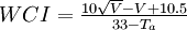

 is the wind chill index based on the Celsius scale,
  is the air temperature in °C, and
  is the air speed in km/h measured at 10


