To use all functions of this page, please activate cookies in your browser.
My watch list
my.chemeurope.com
my.chemeurope.com
With an accout for my.chemeurope.com you can always see everything at a glance – and you can configure your own website and individual newsletter.
- My watch list
- My saved searches
- My saved topics
- My newsletter
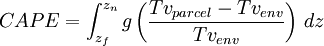
Convective available potential energyIn meteorology, convective available potential energy (CAPE) [1], sometimes, simply, available potential energy (APE), is the amount of energy a parcel of air would have if lifted a certain distance vertically through the atmosphere. CAPE values are valuable in predicting severe weather. Product highlight== Mechanics == CAPE exists within the conditionally unstable layer of the troposphere, the free convective layer (FCL), where an ascending air parcel is warmer than the ambient air. CAPE is measured in joules per kilogram of air (J/kg). Any value greater than 0 J/kg indicates instability and the possibility of thunderstorms. Generic CAPE is calculated by integrating vertically the local buoyancy of a parcel from the level of free convection (LFC) to the equilibrium level (EL):
Where zf and zn are, respectively, the heights of the levels of free convection and equilibrium (neutral buoyancy), Tvparcel is the virtual temperature of the specific parcel, Tvenv is the virtual temperature of the environment, and g is the acceleration due to gravity. CAPE for a given region is most often calculated from a thermodynamic or sounding diagram (e.g., a Skew-T log-P diagram) using air temperature and dew point data usually measured by a weather balloon. CAPE is effectively positive buoyancy, expressed B+ or simply B; the opposite of convective inhibition (CIN), which is expressed as B-, and can be thought of as "negative CAPE". As with CIN, CAPE is usually expressed in J/kg but may also be expressed as m2/s2, as the values are equivalent. In fact, CAPE is sometimes referred to as positive buoyant energy (PBE). This type of CAPE is the maximum energy available to an ascending parcel and to moist convection. When a layer of CIN is present, the layer must be eroded by surface heating or mechanical lifting, so that convective boundary layer parcels may reach their LFC. On a sounding diagram, CAPE is the positive area above the LFC, the area between the parcel's virtual temperature line and the environmental virtual temperature line where the ascending parcel is warmer than the environment. Neglecting the virtual temperature correction may result in substantial relative errors in the calculated value of CAPE for small CAPE values[2]. CAPE may also exist below the LFC, but if a layer of CIN {subsidence) is present, it is unavailable to deep, moist convection until CIN is exhausted. When there is mechanical lift to saturation, cloud begins at the lifted condensation level (LCL); absent forcing, cloud base begins at the convective condensation level (CCL) where heating from below causes spontaneous buoyant lifting to the point of condensation when the convective temperature is reached. When CIN is absent or is overcome, saturated parcels at the LCL or CCL, which had been small cumulus clouds, will rise to the LFC, and then spontaneously rise until hitting the stable layer of the equilibrium level. The result is deep, moist convection (DMC), or simply, a thunderstorm. When a parcel is unstable, it will continue to move vertically, in either direction, dependent on whether it receives upward or downward forcing, until it reaches a stable layer (though momentum, gravity, and other forcing may cause the parcel to continue). There are multiple types of CAPE, downdraft CAPE (DCAPE), estimates the potential strength of rain and evaporatively cooled downdrafts. Other types of CAPE may depend on the depth being considered. Other examples are surface based CAPE (SBCAPE), mixed layer or mean layer CAPE (MLCAPE), most unstable or maximum usable CAPE (MUCAPE), and normalized CAPE (NCAPE).[3] Significance to thunderstormsThunderstorms form when air parcels are lifted vertically. Deep, moist convection requires a parcel to be lifted to the LFC where it then rises spontaneously until reaching a layer of non-positive buoyancy. The atmosphere is warm at the surface and lower levels of the troposphere where there is mixing (the planetary boundary layer (PBL)), but becomes substantially cooler with height. The temperature profile of the atmosphere, the change in temperature, the degree that it cools with height, is the lapse rate. When the rising air parcel cools more slowly than the surrounding atmosphere, it remains warmer and relatively less dense. The parcel continues to rise freely (convectively; without mechanical lift) through the atmosphere until it reaches an area of air less dense (warmer) than itself. The amount of and shape of the positive area modulates the speed of updrafts, extreme CAPE can result in explosive thunderstorm development; such rapid development usually occurs when CAPE stored by a capping inversion is released when the "lid" is broken by heating or mechanical lift. The amount of CAPE also modulates how low-level vorticity is entrained and then stretched in the updraft, with importance to tornadogenesis. The most important CAPE for tornadoes is within the lowest 1 to 3 km (0.6 to 1.9 mi), whilst deep layer CAPE and the width of CAPE at mid-levels is important for supercells). Tornado outbreaks tend to occur within high CAPE environments. Large CAPE is required for the production of very large hail, owing to updraft strength, although a rotating updraft may be relatively stronger with less CAPE. Large CAPE also promotes lightning activity.[4] Two notable days for severe weather exhibited CAPE values over 5,000 J/kg. Two hours before the Oklahoma Tornado Outbreak occurred on May 3, 1999, the CAPE value sounding at Oklahoma City was at 5,885 J/kg. A few hours later, an F5 tornado ripped through the southern suburbs of the city. Also on May 4, 2007 CAPE values of 5,500 J/kg were reached and an EF5 tornado tore through Greensburg, Kansas. On these days, it was apparent that conditions were ripe for tornadoes and CAPE wasn't a crucial factor. However, extreme CAPE, by modulating the updraft (and downdraft), can allow for exceptional events, such as the deadly F5 tornadoes that hit Plainfield, Illinois on August 28, 1990 and Jarrell, Texas on May 27, 1997 on days which weren't readily apparent as conducive to large tornadoes. CAPE was estimated to exceed 8,000 J/kg in the environment of the Plainfield storm and was around 7,000 J/kg for the Jarrell storm. Severe weather and tornadoes can develop in an area of relatively low CAPE values. The surprise severe weather event that occurred in Illinois and Indiana on April 20, 2004 is a good example. Importantly in that case, was that although overall CAPE was weak, there was strong CAPE in the lowest levels of the troposphere which enabled an outbreak of minisupercells producing large, long-track, intense tornadoes.[5] See alsoReferences
|
||
| This article is licensed under the GNU Free Documentation License. It uses material from the Wikipedia article "Convective_available_potential_energy". A list of authors is available in Wikipedia. |
Last viewed


